Calumet Connect Databook
Chicago’s vibrant Southeast Side is rich in water resources. It’s home to Lake Michigan, Lake Calumet, Big Marsh Nature Preserve, and the Calumet River, which courses through the community.
But the Calumet River is heavily industrialized. Its shoreline is dominated by industry, leaving little access for people to enjoy the water. The steel mills that once operated here left a legacy of industrial pollution. And for the past decade, community activists have been fighting to prevent new pollution sources and clean up existing sources that threaten public health.
Now the community is at crossroads, The City of Chicago will soon begin work on a new plan to revitalize the Calumet River corridor. It’s essential that residents and the city’s Department of Planning have accurate information to make decisions that can guide sustainable development and protect public health.
What’s in the Databook?

The Databook has been compiled to serve as a resource in guiding policy and planning in the Calumet Industrial Corridor. The Databook is the product of more than a year of collaborative research.
The findings in the Databook draw on both quantitative and qualitative methods of evaluating the study area and the quality of life for residents. Topics include Industrial Occupation and Land Use, Permitting Violations, Health Outcomes and Services, Incentives and Real Estate Activity, Community Needs Assessment, and Health Impacts of Climate Change in the Calumet Industrial Corridor.
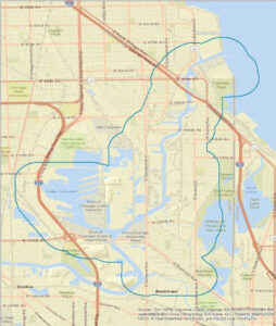
About the Study Area

The Calumet Industrial Corridor is the largest industrial corridor by land area in Chicago.
- 73% of the corridor is part of a Planned Manufacturing District.
- The study area for the Databook project consisted of the Calumet Industrial Corridor and the surrounding half-mile. As of 2017:
- Hispanic/Latino residents made up 58.96% of the study area population.
- Black residents made up 25.02% of the study area population.
Key Findings

- Disproportionate Health Outcomes: Residents of the Calumet Industrial Corridor disproportionately experience adverse health outcomes.
- The rate of coronary heart disease is higher in the study area compared to the rest of Chicago; this is also true when comparing to the other industrial corridors.
- The rate of COPD is higher in the study area compared to the rest of Chicago.
- Medically Underserved Area: Large portions of the study area remain “medically underserved areas” – a term designated under the Health Resources and Services Administration – where residents face a shortage of primary health care services.
- Toxic Releases: Toxic releases remain at high levels in parts of the study area.
- The study found several polluters with sustained high scores in the Corridor.
- Some industries, in particular, showed consistently high scores.
For example: In 2012, the auto industry vastly outpaced all other industries. But by 2017, the toxic releases from just one company, American Zinc Recycling Corp., had grown to have the highest RSEI score of any polluter within the Corridor.

- Failures of Zoning and Land Use Policies: The City’s current and recently proposed land use and zoning policies are not sufficient to support the community’s goals for a healthy and environmentally just Corridor.
- From the 1990s to the 2010s, the Calumet Industrial Corridor increased “transportation/communication/utilities/waste” uses and “institutional” uses at the expense of residential and commercial uses.
Recommendations

- Public Health Focus: Future planning in the Corridor should incorporate and prioritize public health considerations.
- Residents’ Voices: When City agencies make future planning decisions, they should seek out, listen to, and center residents’ voices.
- Discuss Immediate Changes: In consultation with the community, the City must commit to real changes. These might include:
- Stricter regulations, more frequent inspections, more severe penalties, and greater transparency.
- The City re-evaluating its economic incentive programs to attract more sustainable businesses to the Corridor.
- Further Research: More data is needed. And for data that is already publicly available, transparency and restructuring should be prioritized.
- The Databook working group seeks the active involvement of the Department of Planning and Development in collecting and sharing data.

Read the Databook
- Download the Databook
- Executive Summary
- Quantitative Phase I: Industrial Occupation and Land Use, Permitting Violations, and Health Outcomes and Services
- Qualitative: Community Needs Assessment
- Quantitative Phase II: Incentives and Real Estate Activity
- Appendix: Health Impacts of Climate Change in the Calumet Industrial Corridor
Learn More
Calumet River communities seek a clean water future (Crain’s Chicago Business, Jan. 21, 2021)
Contributors
Thank you to the many organizations that contributed to the Databook, including:
Partners – Alliance for the Great Lakes; Metropolitan Planning Council, Center for Neighborhood Technology, NeighborSpace; Great Lakes Integrated Science and Assessment Center, UI-Chicago School of Public Health, and UI-Chicago Voorhees Center
Calumet Connect Partnership Advisory Committee – Claretian Associates, Southeast Environmental Task Force, Southeast Side Coalition to Ban Pet Coke, Metropolitan Family Services, Work2gether4peace, Southeast Youth Alliance, Parents of Extraordinary Children, Nine3 Studios, Centro De Trabajadores Unidos, and Alliance of the Southeast
Funders – The Chicago Community Trust, Great Lakes Integrated Sciences and Assessments (GLISA), The JPB Foundation through The Funders Network, and Pisces Foundation
