 |  |
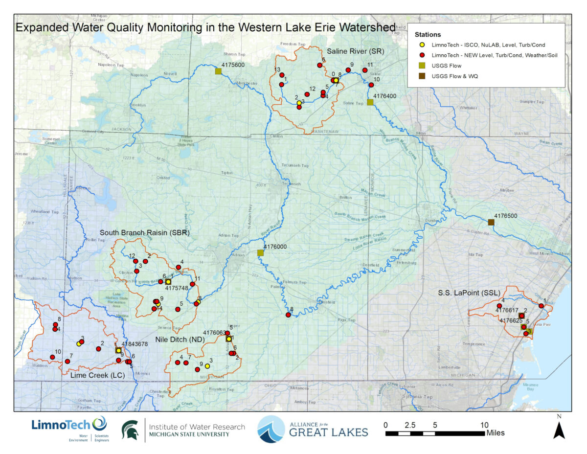
Expanded Water Quality Monitoring in the Western Lake Erie Watershed
Each summer, Western Lake Erie suffers an algal bloom so large it can be seen from space. This harmful algal bloom can make water toxic to fish, wildlife, pets, and people. It creates “dead zones” where fish and other aquatic creatures are unable to live. It pollutes the source of communities’ drinking water, harms the region’s vital tourism economy, and prevents residents and visitors from enjoying boating, swimming, and visiting Lake Erie shorelines.
Lake Erie’s algae blooms are driven by nutrient runoff, primarily from agricultural land uses, which enters streams and tributaries to Lake Erie. The runoff contains high levels of nutrients like phosphorous, which are vital for growing plants. But too much phosphorus in our waterways has disastrous results including harmful algal blooms and dead zones.
To prevent dead zones, toxic drinking water, and damage to our economy and environment, it’s critical to reduce the amount of nutrients entering rivers and streams in the Western Lake Erie Basin.
MDARD partnership will improve water quality monitoring
Understanding, tracking, and predicting where nutrient pollution comes from has been difficult due to weather and cropping complexities and a lack of data. This makes it difficult to properly target where conservation funding should be spent.
Through a $4.86 million grant from the Michigan Department of Agriculture and Rural Development (MDARD) and a $600,000 grant from the Erb Family Foundation, the Alliance for the Great Lakes is working in partnership with MDARD to increase the agency’s ability to track and monitor water quality in five of Michigan’s priority sub-watersheds of the Western Basin of Lake Erie. Technical assistance is being provided by the Michigan State University Institute of Water Research and LimnoTech.
The partnership aims to increase monitoring capacity by deploying higher spatial density monitoring instrumentation with a particular focus on understanding phosphorus trends. The information gleaned from this effort will help MDARD better understand various drivers of nutrient transport and allow for better targeting of conservation efforts to combat nutrient pollution.

The project will run from 2024 to 2029 and cover five of Michigan’s priority sub-watersheds:
- Lime Creek
- Stony Creek (South Branch River Raisin)
- Headwaters of the Saline River
- Nile Ditch
- S.S. LaPointe Drain
Area hydrology, sediment transport, phosphorus transport, and weather conditions in the sub-watersheds will be tracked by the project. Data collection began in Spring 2025 and data is publicly available. To learn more, contact one of the project partners listed below.
Learn more about the project
- Project Summary
- Current Project Management Plan – This plan will be updated regularly.
- Pushing Lake Science Upstream: Agriculture and Algal Blooms at Lake Erie – Article in Environmental Monitor, July 14, 2025
- Water Quality Monitoring in the Western Lake Erie Basin – Video, June 9, 2025
- WLEB 2025 Winter Webinar Series: High Density Water Quality Monitoring – Webinar, February 26, 2025
- Monitoring Milestone in Fight Against Lake Erie Pollution – Press release, October 24, 2024
For more information, contact:
Alliance for the Great Lakes: Angela Blatt, Senior Agriculture Policy Manager, ablatt@greatlakes.org
Freeboard Technology / LimnoTech: Ed Verhamme, President / Principal, everhamme@limno.com
Michigan State University Institute of Water Research: Jeremiah Asher, Assistant Director, asherjer@msu.edu