Yesterday, the International Joint Commission announced the enactment of Plan 2014.
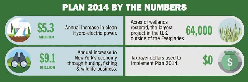
Plan 2014 implements a more natural way of managing water levels on Lake Ontario and the St. Lawrence River. Water levels on the lake and river are regulated due to a large hydro-power dam downstream. A more natural approach to water levels regulation will improve the health of nearly 64,000 acres of wetlands. Healthy wetlands will lead to improved water quality and habitat for fish and wildlife. The new plan is the first major update to Lake Ontario and St. Lawrence River regulation in more than 50 years.
Nate Drag, our Watershed Project Manager based in Buffalo, New York, shares his reflections on the news:
A few years ago, while in Michigan for a conference, I stopped by one of the state’s many breweries. While in the gift shop, I noticed a tote bag that had an image of the Great Lakes on it and was immediately drawn to it. After a few seconds, I noticed something was missing. I asked the sales clerk why they left off one of the Great Lakes. The clerk gave me a confused look and said she had never noticed a lake was missing.
The bag with the slogan “Great Lakes, Great Beer” had completely left off Lake Ontario from its drawing of the Great Lakes.
I later showed the bag to a colleague and asked if he noticed anything missing, to which he promptly stated that they left out the St. Lawrence River. A bit embarrassed, I realized that I had forgotten about the river in my frustration over Lake Ontario’s absence.
My point in sharing this story isn’t to talk about a couple of guys from New York feeling left out in a brewery gift shop. Nor is it to point fingers at an excellent brewery that makes amazing beer. It’s to talk about the need to view our Great Lakes as an entire system. What happens on one end – for better or worse – impacts the whole basin.
Balancing the environment and the economy
On the surface, yesterday’s announcement of the approval of Plan 2014, which will create a more naturalized water level regime for Lake Ontario and the St. Lawrence River, seems to have a pretty limited geographic impact. Unless you are from upstate New York or eastern Ontario, you probably have never heard of Plan 2014.
But with its approval by the federal governments of Canada and the United States, this plan showcases a decision making process that placed the ecosystem of the Great Lakes on par with the economies and communities in the region. The model of Plan 2014’s balanced approach can lead us in a more sustainable direction.
Variability critical to lake and river health
Plan 2014 is the first update to the water level regulation plan for Lake Ontario and the St Lawrence River since the completion of the Moses-Saunders Power Dam in 1958. Since the 1950’s, water levels have been artificially stabilized on the lake and river to provide consistency for hydropower production and shipping.
At first glance, controlled water levels seems like a good idea. Who doesn’t like stability? However, water levels variability is critical to the health of rivers and lakes, particularly wetlands. Wetlands act like the heart and lungs for rivers and lakes. Without healthy heart and lungs, rivers and lakes cannot thrive.
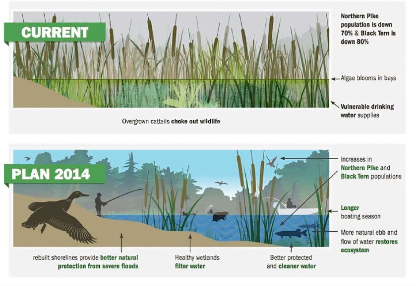
The past 58 years of controlled water levels provided consistent hydro-power production, shipping, and shoreline development on the lake and river. But it also denied fragile wetlands the water level fluctuation they require. Wetlands are crucial habitat for native Great Lakes species like northern pike and common tern.
The decline of coastal habitats impacted the wildlife that depend on them as well as the communities that rely on the multi-million dollar tourism, hunting, and fishing industries. Artificially stabilized water levels resulted in coastal areas along Lake Ontario and the St. Lawrence river that:
- lacked biodiversity,
- made them vulnerable to increased flooding and erosion,
- created conditions for increased algae blooms and,
- reduced the ability of wetlands to improve water quality by filtering out pollution.
The approval of Plan 2014 will restore 64,000 acres of these essential wetlands. Most importantly, this restoration will happen with no additional taxpayer investment from taxpayers. By allowing Lake Ontario and St. Lawrence River water levels to fluctuate more naturally, while still avoiding extreme level changes, these wetlands will recover through natural processes.
Collaboration critical for strong Great Lakes
The approval of the plan does not end the story. The new water level plan will require collaboration with shoreline communities that are facing the challenges of living on the shores of ever changing waterways. Communities along Lake Ontario and the St. Lawrence River continue to face challenges due to climate change and extreme weather.
But by building new partnerships, our waterways and our communities will be stronger and more resilient on Lake Ontario, the St Lawrence River, and the entire Great Lakes basin.
Balancing the interest of shoreline communities, commercial and recreational use of waterways, and ecosystem benefits should be applied to every key decision the Great Lakes will face in the future.
From decisions on crude oil pipelines in sensitive areas or protecting the lakes from new invasive species, giving ecological concerns equal standing to the social and economic concerns is the right path creating a sustainable Great Lake region in the 21st century.